Flank instability and magma propagation of La Palma, Canary Islands
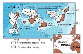
Figure 1. The geographic location of La Palma off the northwestern coast of Africa
(Ward, S.N., Day, S.J., 2001).
GEOPHYSICAL DATA
La Palma is one the two western most island of the Canary Islands, a 500-km-long chain of seven intraplate volcanic islands off the northwestern African continental shelf. La Palma is roughly 43.5 km long, 27 km wide and rises approximately 2426 m (7959 ft) above sea level (Kluegel et al., 1999).
ERUPTIVE HISTORY
The 1949 eruption on La Palma emanated from the Cumbre Vieja Ridge. The Cumbre Vieja ridge lies in the southern third of La Palma on the N-S portion of the Mercedes Star Ridge system. The Cumbre Vieja eruption of 1949 started with a phreatomagmatic explosion at the Duraznero vent on June 24th. On July 8th the Llano del Banco fissure opened emitting lava at high rates for eighteen days. On July 12th the Hoyo Negro vents became active, violently erupting for ten days. July 30th, Hoyo Hegro erupts briefly; Duraznero fissure opens spewing a short but intense fire-fountian eruption (Day et al. 1999).
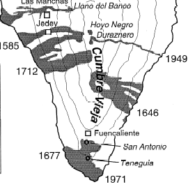
Figure 2. Displays the vents of the 1949 Cumbre Vieja eruption (Kluegel et al. 1999)
MAGMA ASCENSION
The magma supplying the Cumbre Vieja Volcano is believed to ascend in one of two ways. The first is that is magma is brought up from depth in a single conduit beneath the Caldera de Taburiente (Kluegel et al., 1999). From there the magma propagates south along the Cumbre Nueva and Cumbre Vieja ridges by shallow dikes. The second is that a singular dike bearing NW at depth ascends and is rotated to a N-S orientation upon reaching the surface (Day et al. 1999).

Figure 3. Day's hypothesis of magma ascension to the Cumbre Vieja Volcano (Day et al. 1999)
FLANK COLLAPSE
The western flank of the Cumbre Vieja volcano lies atop an old collapse scar. Along the N-S ridge of the Cumbre Vieja lies a west dipping detachment Fault,
dipping at approximately 60˚ (Dat et al. 1999). It is believed that a future eruption will trigger the collapse of the western flank of La Palma.
The worst case scenario is a 500 km3 reaching 100 m/s before reaching run out. Nine hours later waves 10-25 m (33-82ft) would reach the eastern coast of the United States (Ward, S.N., Day, S.J., 2001).
REFERENCES CITED
Day, S.J., Carracedo, J.C., Guillou, H., Gravestock, P., 1999. Recent structural evolution of the Cumbre Vieja volcano, La Palma, Canary Islands: volcanic rift zone reconfiguration as a precursor to volcano flank instability? Journal of Volcanology and Geothermal Research. 94, 135–167.
Elsworth, D., Day, S.J., 1999. Flank collapse triggered by intrusion: the Canarian and Cape Verde archipelagoes. Journal of Volcanology and Geothermal Research. 94, 323–340.
Kluegel, A., Schmincke, H.-U., White, J.D.L., Hoernle, K.A., 1999. Chronology and volcanology of the 1949 multi-vent rift-zone eruption on La Palma Canary Islands . Deformation and flank instability of oceanic island volcanoes. Journal of Volcanology and Geothermal Research. 94, 267–282.
Ward, S.N., Day, S.J., 2001. Cumbre Vieja -- Potential collapse and tsunami at La Palma, Canary Islands. American Geophysical Union.