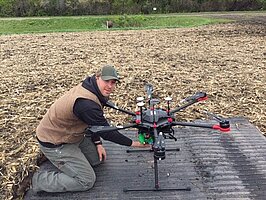
Using UAV and Ther mal Imaging to Deter mine Soil Moisture in Red River Valley

Talon Mack grew up in rural eastern Montana where water resources are limited. Precision agriculture is the key in preserving water and increase crop yields in these areas. With that background, he received his Associate Science degree from Lake Region State College in Devils Lake, with a focus on math, science, and precision agriculture. Later, he transferred to the Agricultural and Biosystems Engineering Department (ABEN) at North Dakota State University (NDSU) in the fall of 2014 as a B.S. student and graduated in December 2016. In the spring 2018 semester, he rejoined the ABEN department as a M.S. student under Dr. Xinhua Jia. His M.S. thesis committee members are Dr. Xin Sun from ABEN and Dr. Stephanie Day from Geosciences.
Using UAV and Thermal Imaging to Determine Soil Moisture in Red River Valley
Research Abstract
Soil moisture is the water stored in the soil. Knowing the soil moisture conditions in a timely matter will be extremely beneficial to farmers, because based on the moisture conditions, farmers can make quick decisions on planting time, crop types, crop varieties, fertilizer types and amounts, equipment operation, and water management strategies. To obtain a timely soil moisture map at a field scale, a UAV will be the best tool. In-situ measurement by soil moisture sensors or soil sampling is too scarce. Remote sensing estimate covers large areas, but its measurement is too coarse with less frequency. In this project, we will measure the soil moisture contents for a 55 ha tile drained testing field, located 32 km from NDSU campus in the MN side of the Red River Valley (RRV). We will determine the soil moisture status using thermal and/or near infrared cameras with UAVs during no crop or short crop periods in late fall or early spring. The estimated soil moisture values will be compared and validated with soil moisture contents measured in the field during the flight time. The results can be extended to other farm fields in the RRV and benefit more people.
Research Highlights
Using remotely sensed images collected by an unmanned aerial vehicle (UAV), a soil water content map was created for a field in the Red River Valley, which explored/expanded the possibility/potential of using UAV in water resources discipline. In 2019, several UAV flights were conducted to collect multispectral and thermal images. During the flights, soil water contents were also measured on the ground using a time domain reflectometer (TDR) at depths of 5 and 15 cm. The TDR was calibrated in the laboratory using the gravimetric method. Using the near infrared (NIR) and red bands, soil water content maps were developed for the field. The estimated and the measured soil water contents using the UAV and the TDR were in good agreement with a coefficient of determination greater than 0.7. However, the processing time and computing power needed to produce such soil water maps were challenging and difficult for a producer. Future research should focus on developing programs to help on the map development. With some of the experience gained from this first UAV project, more research can be conducted to further explore the use of UAVs for other purposes in the field of water resources.

Xinhua Jia, P.E., Professor
Morrill Hall Room 204
Department of Agricultural and Biosystems Engineering
North Dakota State University
NDSU Dept. 7620PO Box 6050
Fargo ND 58108-6050
Phone: (701) 231-6453
E-mail: xinhua.jia@ndsu.edu


