Digital Applications for In-Field Scouting of Weeds and Pests
(Research Report, Carrington REC, December 2021)Introduction
The increase and continued expansion of noxious weeds in North Dakota represent a potential danger to the region’s agricultural markets. North Dakota state law mandates that weeds identified or listed as noxious and troublesome must be controlled. Currently, North Dakota offers regular updates and recommendations for chemical control for a variety of troublesome and noxious weeds. In addition, information pertaining to biological control may be found by contacting the North Dakota Department of Agriculture or local staff of the United States Department of Agriculture - Animal and Plant Health Inspection Service. North Dakota Extension Weed Specialist and Assistant Professor Joe Ilkey has revised a guide to noxious and troublesome weeds in North Dakota, under original authorship by Rodney G. Lym (Ikley, 2020). The recent expansion of palmer amaranth (Amaranthus palmeri) throughout the state is of concern given its propensity to develop herbicide resistance, prolific seed production, and rapid rate of growth. Moreover, palmer amaranth can contribute to decreased yields and gained its notoriety as it impacted the cotton industry in the southern United States. In North Dakota, palmer amaranth is a threat to the state’s primary crops including soybean, sugarbeet, and corn. Perdue University estimates that palmer amaranth has the potential to reduce soybean yields by up to 79%.
Using both the Android and IOS Software Development Kits (SDK) and Geographic Information System (GIS) technology, this mobile application can be rapidly deployed and utilized via a traditional “smartphone” environment. Furthermore, the application is “scalable” meaning that it can evolve as new threats emerge. This relatively new technology offers an efficient and lightweight method for monitoring the presence and spread of noxious weeds within the state, and will contribute to ongoing mitigation efforts as required under state law. The application uses online web-mapping applications, the Android and IOS SDK’s, and a lightweight mobile application to facilitate real-time collection and mapping. The current beta version allows the user to document one of four different noxious weeds and stores the GPS location, a photograph, the county within which it is located, and the relative prevalence. Further attributes will be defined based on discussions with Extension staff and weed specialists.
Mobile Application Development
The mobile application was developed using AppStudio Developer and ArcGIS AppStudio Player (for deployment), and is currently packaged as a deployable Android Package Kit (APK). The application was designed with ease-of-use in mind. The application was designed to record the data and push it to the web map/dashboard in just minutes. Should an individual find themselves in an area of limited cellular phone service, the application allows saving a draft of the incident until a cellular phone signal becomes available. Once “New” is clicked, the user will be brought to an informational page describing what information should be provided (Figure 1). To the extent possible, data is populated via drop-down menus and text boxes to facilitate rapid data collection (Figure 2). Step one is to select the Report Type. The location, obtained via the mobile device’s integrated GPS chip, will appear on a map of the area on the user’s device. Once the location has been identified and the user clicks “Next”, they will have the opportunity to add up to six attachments. This would allow Extension agents, for example, to attach images of the leaves, petioles, and whole plant. After the attachments are made, the user can click “Next” and enter the attribute information from drop down menus, text boxes, and other form elements. Once the attributes have been collected the user clicks on the “Summary” button. This brings the user to the final screen where they may save the incident for later submission or submit the record.
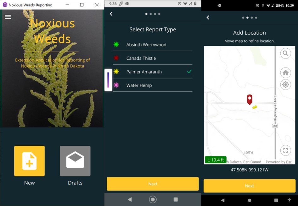
Figure 1: Initial report form screens and location screens. By selecting “New”, the user can then select the report type. In this case, the selected type is palmer amaranth. The next screen allows the user to collect the GPS position using the GPS chip in their mobile device.
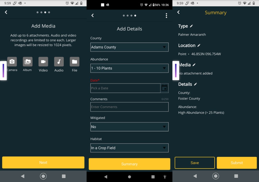
Figure 2: The “Add Media” screen allows the user to upload a picture. The “Add Details” screen prompts the user to enter relevant information pertaining to the location, abundance, mitigation status, and habitat. The “Summary” screen allows the user to save or immediately submit the records.
Summary
This application represents a “first” effort to develop technology that will aid in monitoring the spread of noxious weeds (and/or pests) in North Dakota. The real-time mapping capabilities provide a robust framework within which we can obtain actionable data for decision-making purposes.
The prototype uses a lightweight, but powerful platform that provides an easy-to-navigate application. Moreover, this platform may prove itself useful for other tasks such as Integrated Pest Management. As geospatial technologies become more integrated into our everyday lives, we will continue to see the development of novel applications to aid in our day-to-day tasks.